Objective 1: Enhance Community Engagement and Establish Community Ownership
A resident-driven approach to development, grounded in community capacity building and collective ownership, is the key to equitable revitalization in Coney Island. By building local leadership, fostering partnerships, and launching a pilot community land trust project, Coney Island can develop spaces that reflect resident priorities, promote long-term affordability, and generate sustainable local revenue.
Together, these three recommendations—creating a Community Dashboard, identifying vacant public land, and supporting resident-driven development— work together to strengthen connectedness, empower residents, and position public land as a driver for equity, ownership, and economic resilience in Coney Island.
1.2 Vacant Lot Prioritization and Feasibility Initiative
Develop a comprehensive inventory of vacant, publicly owned land.
Conduct focus groups with community members to envision transformative uses.
Create actionable development plans for prioritized sites.
What is the Vision?
The vision behind this recommendation is to identify, prioritize, and repurpose vacant, publicly owned land through a collaborative, community-driven process. By developing a comprehensive inventory of public land, hosting focus groups, and creating actionable development plans, these sites can be transformed into assets that address community needs, support local ownership, and strengthen Coney Island’s social and economic fabric.
This approach ensures:
Community-Led Planning: Residents will directly shape the vision for how underutilized land can benefit their neighborhood.
Strategic Development: Feasibility studies and mapping will identify opportunities for high-impact projects.
Long-Term Benefits: New community amenities will improve quality of life, promote local revenue generation, and encourage stewardship of neighborhood resources.
Why it Matters
Underutilized publicly owned land in Coney Island represents a major untapped community development opportunity.
Community-driven development can create essential amenities and increase local ownership of assets.
Limited local revenue streams hinder addressing critical community needs.
Coney Island residents have expressed interest in new community assets such as park spaces, community gardens, grocery stores, and truly affordable housing. However, significant portions of public land remain underutilized. These vacant lots represent a unique opportunity to co-create transformative spaces that align with community priorities while generating local revenue and fostering community ownership. As a launching point for other recommendations that include land uses, the importance of this recommendation can’t be overstated as a driver for both equity and economic resilience within Coney Island.
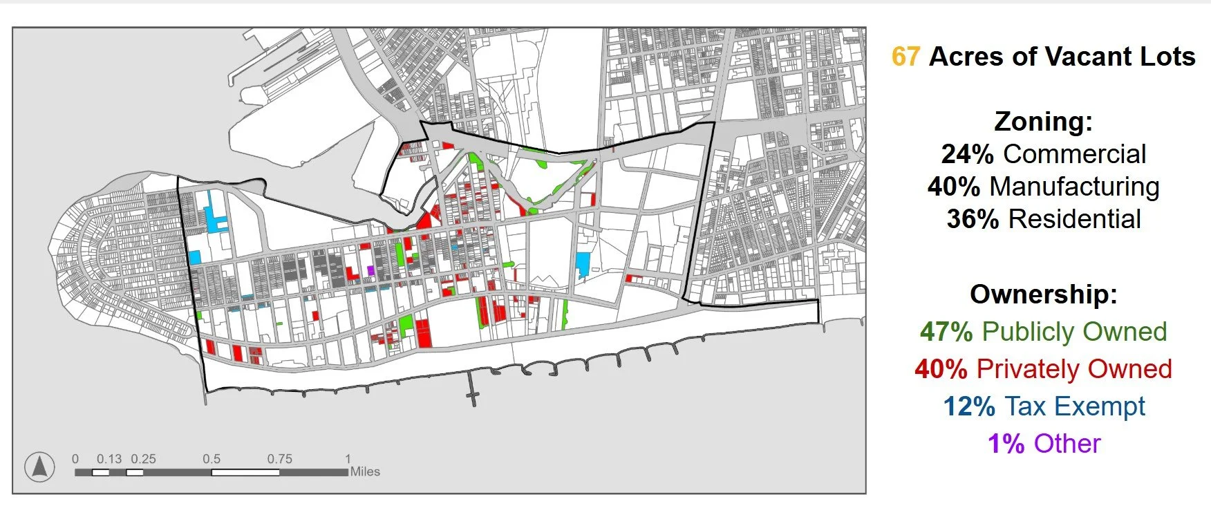
Figure: Vacant Land in Coney Island
There are approximately 67 Acres of Vacant Lots located in Coney Island.
Zoning Breakdown:
24% of total acreage is located in Commercial Zones
40% is located in Manufacturing zones
36% is located in Residential zones
Ownership Breakdown:
47% Publicly Owned
40% Privately Owned
12% Tax Exempt
1% Other
How to Get it Done
Develop a Comprehensive Inventory:
Conduct GIS-based studies to map publicly owned vacant lots by size, ownership agency, zoning, and accessibility.
Update and maintain the inventory to track changes over time and identify high-priority sites.
Engage the Community Through Mapping Workshops:
Host workshops and focus groups to gather resident input on potential uses for vacant land.
Identify priorities based on community needs such as affordable housing, park spaces, grocery stores, and public gathering areas.
Prioritize and Plan:
Prioritize sites based on key indicators such as:
Size and feasibility for development.
Alignment with community-identified needs.
Accessibility to transit, schools, or park space.
Collaborate with residents to create actionable development plans for the most promising sites.
Share Findings and Build Advocacy:
Use the Community Dashboard (Recommendation 1.1) to share updates, maps, and progress with residents.
Work with development partners to align identified priorities with actionable projects.
Stakeholders & Partnerships
Residents:
Central to the visioning process—provide input, share local knowledge, and advocate for priority uses of vacant land.
CINRC:
Serve as the lead agency to coordinate workshops, compile land data, and facilitate partnerships with city agencies and developers.
City Agencies:
NYC Department of City Planning: Provide zoning data and technical guidance on land transfer processes.
NYC Department of Housing Preservation and Development (HPD): Collaborate on housing-related opportunities.
Potential Partners:
Pratt Institute: Support data collection, analysis, and GIS mapping.
Community Land Trusts (CLTs): Explore opportunities for permanent affordability and local stewardship.
Civic Innovation Groups: Provide tools and frameworks for mapping and public engagement.
Potential Funding Sources
NYC Civic Innovation Challenge
Community Development Block Grants
Discretionary funding sources
Local Philanthropic Foundations
Partnerships with nonprofit developers
By identifying and reimagining vacant public land, this recommendation aligns development opportunities with community priorities, strengthening Coney Island’s ability to meet local needs. Through collaboration, transparency, and actionable planning, these spaces can be transformed into vital community assets that foster equity, sustainability, and ownership.